


One of the Oldest Dams in the Country Gets a Check-up
Constructed started in 1863 with a $300,000 loan by Baltimore City to construct a billion gallon reservoir to provide suitable drinking water. Completed in 1871, the dam supported a reservoir that was 750 feet long with a width of 600 feet at the base tapering to 60 feet at the top and covers more than 55 acres. Reconfigured over the years to construct I-83 and the 28th Street exit, the dam still measures 30’ at the top.
The purpose of this evaluation was to perform a routine seepage study
The Robert B. Balter Company (Balter) performed a geotechnical evaluation on the existing Druid Hill Lake slope in Baltimore, Maryland. The slope, which is one of the oldest soil embankment dams in the country, is located west of Interstate 83. A significant settlement event occurred in I-83 directly in front of the dam. Concerned that the settlement was due to a leak in the dam, the Maryland Department of the Environment (MDE) requested that the City of Baltimore perform a study on the dam to confirm that it was still in good working order.
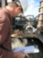
To perform this study a multiple phase approach was taken, with Phase 1 consisting of a records research program and a site reconnaissance. The records research included reviewing all available city documentation, and in-house Balter documents, including boring logs, from the surrounding area. This data provided an understanding of how the dam was constructed and how it has changed over the years. A detailed site reconnaissance was performed which included traversing the entire slope from top to bottom and the full length of the slope. Observations included minor settlements and localized slope failures throughout the slope.
Phase 2 of the study was to perform a geophysical evaluation for the purpose of identifying potential areas of concern (ie, potential water seeps, low density zone, etc.). The study included an electromagnetic survey, a microgravity survey, a spontaneous potential survey, and MASW. The advantage of this study was that it identified areas of potential concern which we were able to focus on and conversely eliminated previously believed areas of concern. Ultimately we were able to reallocate funds to areas of study of those identified in this phase.
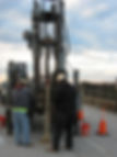
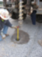
Phase 3 consisted of geotechnical borings located at the top, middle, and toe of the existing dam. The borings were drilled through the entire dam into the underlying rock. The borings were converted into ground water monitoring wells and vibrating wire piezometers for a long-term monitoring program. Soil samples collected were tested for engineering index tests, flex wall permeability, and pin hole flow tests all of which to evaluate the seepage conditions of the dam. Extensive seepage analyses were performed which indicated that this historic earthen dam is still working properly after more than 140 years of use.